Geofencing is a location technology that creates a virtual boundary drawn on a map around a real-world location. In fleet management, these virtual boundaries enable the management of many processes from a single platform, ranging from automatically tracking vehicles entering and exiting specific areas to theft detection, route compliance, and KVKK-compliant reporting. The true value of these virtual boundaries emerges from how they work in the background and what they bring to the field when properly configured.
What is Geofencing?
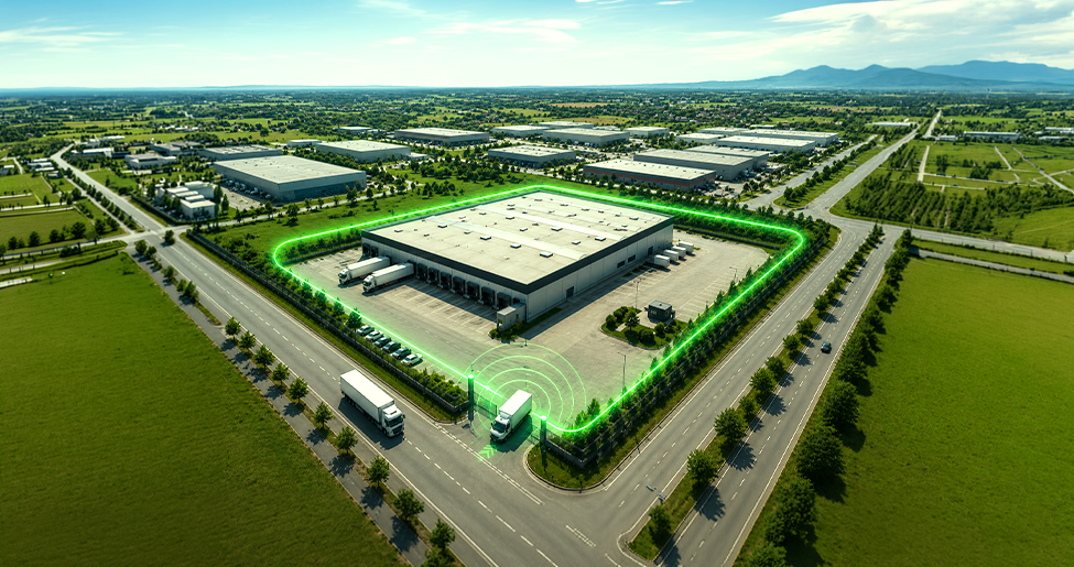
Geofencing is a technology that creates a virtual perimeter or boundary around a specific real-world area by combining GPS, cellular networks, or Wi-Fi signals with advanced mapping software. Also referred to as a “geo-fence,” these virtual boundaries can be defined around a construction site, warehouse, customer address, or any designated area.
When a vehicle enters this boundary, exits the area, or stays within the boundary for longer than a specified duration, the system is automatically triggered and sends an instant notification to the manager. Thus, the fleet manager is only notified when defined rules are violated, without having to monitor each vehicle on the screen individually.
How Does Geofencing Work?
Behind the technology lies the continuous data exchange between the vehicle's satellite positioning module and the fleet management platform. Located on the vehicle vehicle tracking device, transmits the precise coordinate data it receives from satellites to the center.
The software layer instantly compares the incoming latitude and longitude data with the virtual area boundaries pre-drawn in the system. GPS accuracy is at the level of a few meters. The moment the vehicle crosses the virtual line, the software detects the event and takes action according to the defined rule.
On the administrator side, creating a geographical boundary is basically completed in three steps:
- Determination of the area: The point to be monitored is selected; this can be a customer site, warehouse, construction site, or a restricted access area.
- Drawing of the border: A virtual boundary is drawn around this area via the map interface on the fleet management platform.
- Definition of triggers and notifications: It is selected which action (e-mail, app notification, report) will be triggered in situations such as border entry, exit, or staying longer than a certain period.
What Are the Types of Geofencing?
Geofencing is not limited to drawing a circular area. Different configurations are possible depending on operational needs:
| Geofencing Type | Logic of Use | Sample Area |
| Static Zones | They are permanent geofences drawn around fixed-location areas. | Warehouse, bonded warehouse, customer address, or central panel |
| Dynamic Routes | These are corridors where a tolerance distance is left to the right/left of the route. | Certain intercity shipment routes |
| Time-Based Rules | It is the matching of regional boundaries with time constraints. | Vehicle usage outside of working hours |
Geofencing Use Cases in Fleet Management
Virtual boundaries allow for the organization of complex processes in the field with concrete data. Prominent use cases are:
- Route Compliance Tracking: It is checked whether the vehicles go outside the designated corridor, and unnecessary mileage and fuel waste are prevented.
- Theft and Unauthorized Use Detection: When the vehicle is moved outside of working hours or from a secure parking area without authorization, the system alerts the security units or the manager.
- Legislation and Audit Records: Arrival and departure times at the customer site are recorded automatically. These records constitute neutral and objective evidence regarding delivery times and arrival times.
- Construction Site and Field Safety: Vehicles are prevented from approaching dangerous zones or restricted areas, or relevant personnel are notified upon entry.
What are the Differences Between Geofencing and Simple Location Tracking?
Traditional tracking methods and geofencing technology are completely separate from each other in terms of operational logic:
| Feature | Simple Location Tracking | Geofencing |
| Management Approach | Passive (Monitoring historical data) | Proactive (Real-time incident response) |
| Trigger Logic | You need to constantly check the screen. | It automatically generates an alarm at the time of a violation or incident. |
| Focus Point | The current point location of the vehicle | Action taken based on the specified region |
| Decision Support Process | He reports after the event is over. | It mobilizes the moment the incident occurs. |
Things to Consider When Setting Up Geofencing
The efficiency provided by geofencing largely depends on how carefully the setup is done. A misconfigured system either exhausts teams with constant false alarms or undermines trust in the system by missing critical violations. Therefore, the following details must be paid attention to when establishing an effective geographic limitation infrastructure:
- Boundary Sensitivity: Drawing the boundaries too narrow can lead to false alarms due to GPS drift. Keeping them too wide reduces the accuracy of the warning.
- Hardware and Data Continuity: Reliable vehicle tracking devices should be chosen that can transmit the vehicle's location accurately and quickly, and preserve data with their internal battery during GPS/GSM interruptions.
- Correct Notification Structure: Defining every region transition as an alarm creates information pollution. Notification rules for critical regions must be filtered correctly.
How Does Geofencing Data Integrate with Route Optimization and Reporting?
When the entry, exit, and waiting times generated by geofences are combined with smart reporting panels capable of storing 3 years of historical location data route optimization It guides strategic decisions, especially.
Future routes are organized by analyzing wait times at frequently visited customer locations. With the help of heat maps and vehicle density layers, areas where the fleet experiences congestion are identified. This way, time management is made efficient while reducing operational costs.
Make a Difference in Fleet Management with Mobiliz
The proactive control offered by geofencing is made possible by reliable tracking hardware that generates accurate location data and a management platform that turns this data into rules. Mobiliz’s vehicle tracking devices, it ensures the reliable operation of virtual boundaries by transmitting location data without interruption even during GPS/GSM outages; it allows you to manage the entire process from reporting to route optimization by gathering waiting time and violation data on a single screen.